 OSU Pytheas - Data Catalog
relationnal database SQL
Type of resources
Available actions
Topics
INSPIRE themes
Keywords
Contact for the resource
Provided by
Formats
Representation types
Update frequencies
status
Scale
-
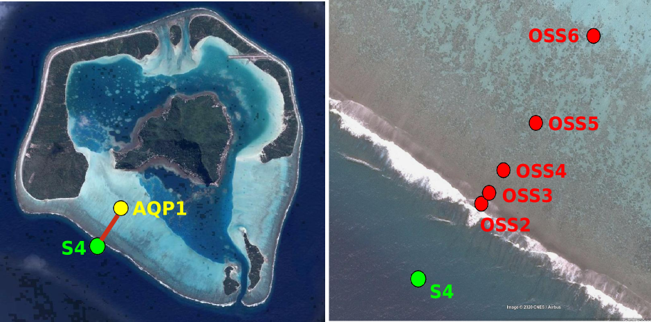
Maupiti ("the Stuck Twins'') is a diamond-shaped island located in the western part of the Society archipelago in French Polynesia. The present study focuses on the data recovered over a single cross-barrier transect located in the south-west barrier during the MAUPITI HOE field campaign, from 5 to 18 July 2018. The studied area is representative of the reef structure observed along the 4km-long southwestern barrier reef, showing an alongshore-uniform structure exposed to swell approaching with weak incident angles, a healthy reef colony. In the cross-barrier direction, the reef displays a clear partitioning of bottom roughness that ranges from low-crested compact structures at the reef crest to higher and sparser coral bommies on the backreef. The experimental setup was specifically designed to analyse and differentiate the dynamics over three roughness-contrasting sections found over the barrier reef. Four pressure sensors (OSS3, OSS4, OSS5, OSS6) have been deployed across the reef flat/ backreef, outside the surf zone. The bottom pressure is measured continuously at 10 Hz, and are converted into free surface elevation assuming hydrostaticity. An electrocurrent meter S4 provides the wave forcing while AQP1 is a velocity profiler providing the transports. The bed profile is obtained from the combination of (I) boat survey in the deeper part and (ii) high resolution GNSS RTK topography by feet. S4 position : -16.47109°N; -152.2782°E OSS3 position: -16.46968°N; -152.27698°E OSS4 position : -16.46931°N; -152.27676°E OSS5 position : -16.46851°N;-152.27614°E OSS6 position: -16.46706°N; -152.27504°E AQP1 position: -16.46318°N ; -152.27348°E
-
CARLIT : Évaluation de l’état écologique du littoral rocheux méditerranéen français – Descripteur ‘Macroalgue’ de la Directive Européenne Cadre sur l’Eau Dans le cadre du contrôle de surveillance DCE-Bassin Rhône côtier Méditerranée, la mise en œuvre du descripteur ‘Macroalgue’ a été mise en place depuis le printemps 2007 en utilisant la méthode CARLIT. Les communautés rocheuses des étages médio- et infralittoraux (frange supérieur de l’étage infralittoral souvent émergée), la géomorphologie et la nature de la roche ont été cartographiées à l’échelle 1/2 500ème. Un niveau de sensibilité écologique face aux perturbations sur une échelle de 1 (peu sensible) à 20 (très sensible) est attribué à chaque communauté. Les communautés ayant les niveaux de sensibilité les plus forts représentent les communautés climax de la zone littorale. Par une analyse géo-référencée, un indice de qualité environnementale est calculé, et permet ainsi de déterminer, pour chaque masse d’eau, un statut écologique établi suivant les critères de la Directive Cadre Européenne sur l’Eau. Les littoraux sédimentaires sont ignorés à l’exception des baies naturelles très fermées où les phanérogames peuvent être abondantes, ainsi que l’intérieur des ports et des marinas. Ces deux dernières zones étant trop perturbées, elles nécessitent l’utilisation d’autres indices comme par exemple l’analyse de l’eau. L’intégralité des côtes rocheuses françaises méditerranéennes a été cartographie (depuis 2007). La méthode CARLIT (CARtographie LITtorale) développée par Ballesteros et al., 2007 et modifié par Blanfuné et al., 2017, consiste à mesurer l'abondance et la distribution des communautés ou espèces de macroalgues dominantes présentes sur les substrats rocheux de l’étage médiolittoral et de l'horizon supérieur de l’étage infralittoral (0-50 cm de profondeur) en fonction de la géomorphologie de la côte (présence de falaise supérieure à 15 m de hauteur) et de la nature du substrat (naturel, artificiel, etc.). L'abondance des communautés est cartographiée à partir d’une petite embarcation longeant la côte au plus près du littoral et à 4-5 km/h. La méthode ne s’applique donc pas à des masses d’eau dont la côte est sableuse, où le descripteur macroalgues n’est pas pertinent. Par une analyse géoréférencée, un indice de qualité environnementale (EQR) est calculé, et permet ainsi de déterminer, pour chaque masse d’eau, un statut écologique (ES) établi suivant les critères de la Directive Cadre Européenne sur l’Eau. Une deuxième vague d’évaluation a commencé depuis 2012.
-
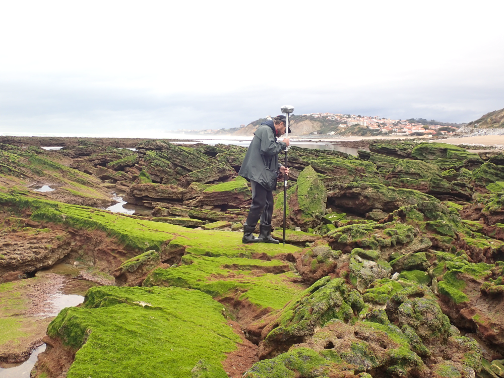
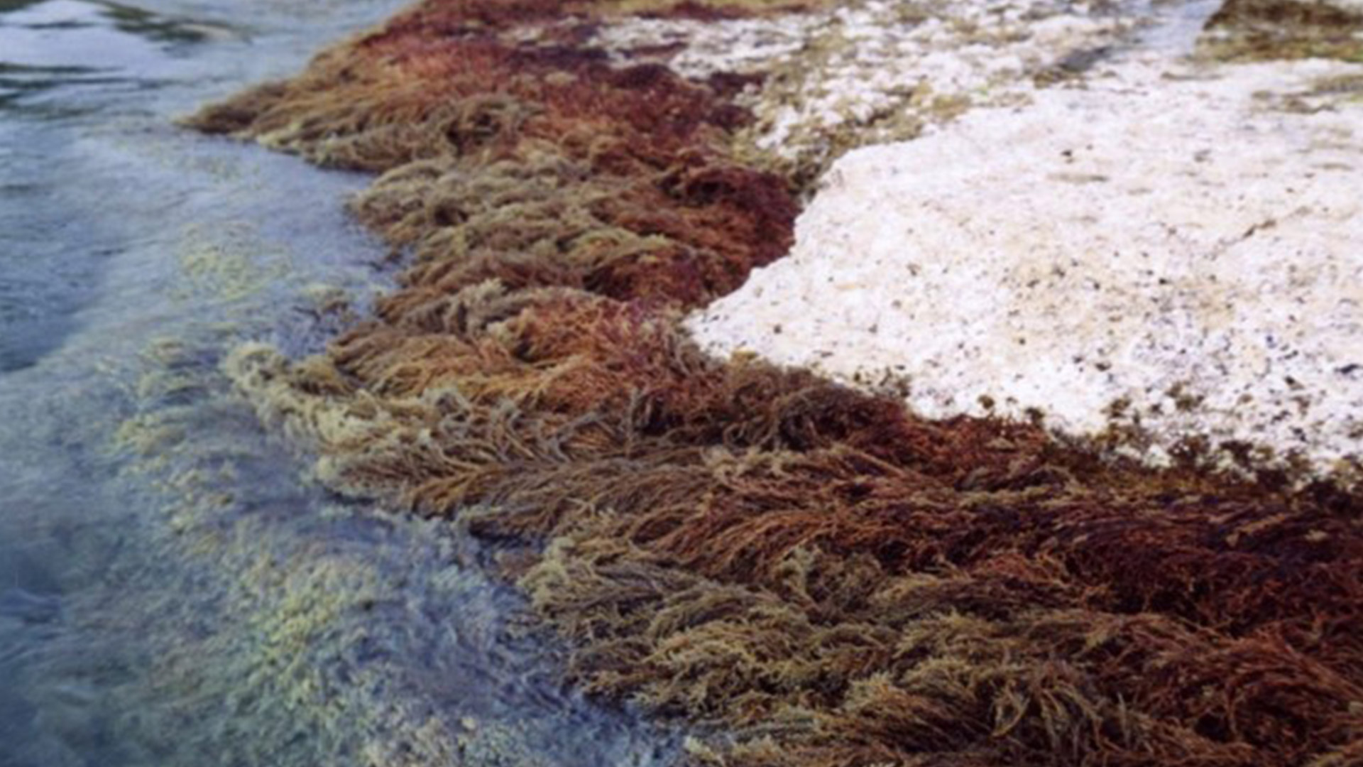
The present dataset is based on a nine site study of fine seabed topography in intertidal zones. Four coral sites (Maupiti A, B and C and Niau islands) and five rocky sites (Ars en Ré, Socoa, Parlementia A and B and Banneg island) have been explored. The data has been gathered using on-foot GNSS RTK for all sites (Trimble R8/R8S and Leica sytems) except Banneg island, where aerial Lidar data from Litto3D program has been used. The horizontal resolution varies between 3.8 and 12cm allowing to describe a wide range of spatial scales (generally over 3 spectral decades). The data has been processed to explore the statistical and spectral metrics which can be used to characterize the architectural complexity of seabeds. Owners: - Topographic survey on Ars-en-Ré : profile X, Z in meter along a transec was operated on 10-15 Jan 2021 with On-foot Trimble R8/R8S GNSS RTK by Shom, Gladys and Univ. de Montpellier - Topographic survey on Maupiti Hoe: profile X, Z in meter along a transec was operated on 5-10 July 2018 with on-foot Trimble R8/R8S GNSS RTK by GLADYS and Université de Montpellier - Topographic survey on Niau : profile X, Z in meter along a transec operated on 10 Nov. 2021 with On-foot Trimble R8/R8S GNSS RTK - by CEREGE and MIO (OSU Pytheas) - Topographic survey on Parlementia A, and B : profile X, Z in meter along a transec was operated on 22 Fev 2023 with on-foot Leica GNSS RTK by SIAME, UPPA - Topographic survey on Socoa : profile X, Z in meter along a transec was operated on 21 Fev 2023 with on-foot Leica GNSS RTK by SIAME, UPPA and Shom - Topographic survey in high resolution of Banneg island (X, Y, Z) is made by aerial lidar litto3D on spring 2012/2013 by Shom and IGN
-
The scientific objectives of the project MAUPITI HOE are to understand the hydrodynamics of an archetypal reef-lagoon system of a high volcanic reef island. The physical functioning of the hydrosystem involves a fine coupling between water levels, waves (including wind, infragravity and VLF waves), currents and seabed structure (reef roughness). The present data focuses on the reef barrier dynamics. Citation: - Sous D., Bouchette F., Certain R., Meulé S. (2021). Maupiti Hoe 2018 [Data set]. MIO UMR 7294 CNRS, GLADYS. https://doi.org/10.34930/9DB3BEC4-0BBF-4531-8864-F100C4B8ECED
-
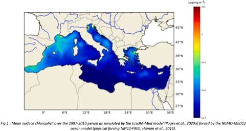
"Towards an integrated prediction of Land & Sea Responses to global change in the Mediterranean Basin" The LaSeR-Med project aims at investigating the effects of climate change and of mediterranean population growth on some major indicators of the Mediterranean Sea (primary production, carbon export, zooplankton biomass available for small pelagic fishes, pH, dissolved oxygen) using and integrated model encompassing a socio-economic model, a continental model of agro-ecosystems, and a physical ocean-atmosphere model coupled to a biogeochemical model of the ocean. Last, a model for the widespread species of jellyfish Pelagia Noctiluca (Berline et al., 2013) uses biogeochemical outputs as food forcing for the jellyfish. In this project, our first aim was to investigate the large-scale and long-term impacts of variations in river inputs on the biogeochemistry of the Mediterranean Sea over the last decades (see Pages et al., 2020a). This interdisciplinary project provided the framework for joint discussions on each of the sub-models that constitute the integrated model, namely the socio-economic model (Ami et al., in prep., Mardesic et al., in prep.) created ex nihilo by researchers from AMSE, INRA and GREQAM, the continental agro-ecosystem model LPJmL (Bondeau et al., 2007) worked on at IMBE so as to include the nitrogen and phosphorous cycles in the frame of the present project, and the ocean biogeochemical model Eco3M-Med developed at MIO (Baklouti et al., 2006; Alekseenko et al. 2014, Guyennon et al., 2015; Pagès et al., 2020a), forced by ocean physics, either using the ocean model NEMO-Med12 forced by atmosphere at IPSL (simulation NM12-FREE run with the NEMO-MED12 model and used for our hindcast simulation, see below) or a coupled ocean-atmosphere model at CNRM (physical forcing provided by CNRM-RCSM4, see below). Details on simulation NM12-free: The historical simulation used in this work is referred to as the NM12-FREE (no reanalysis no data assimilation) which started in October 1979 and ended in June 2013 (Hamon et al., 2016). It has been run with the general circulation model NEMO in its regional configuration NEMO-MED12 based on a horizontal resolution of 1/12 de degree (6.5 to 8 km cells) and a 75-level vertical resolution (of 1 m width at the surface to 135 m at the seabed). For this simulation, runoff and river inputs in the NM12 domain came from the inter-annual data of Ludwig et al. (2009) and the atmospheric forcing was based on the dynamical downscaling of the ERA-INTERIM reanalysis, i.e. ALDERA which has a 12 km spatial resolution and a 3 h temporal resolution. More details on the NM12-FREE simulation are given in Hamon et al. (2016). Keywords: - Mediterranean Sea, river inputs, chlorophyll, nutrients, phytoplankton, bacteria, zooplankton, dissolved and particulate organic detrital matter Citation: Pagès, R., Baklouti, M., Barrier, N., Richon, C., Dutay, J.-C., and Moutin, T. (2020a). Changes in rivers inputs during the last decades significantly impacted the biogeochemistry of the eastern Mediterranean basin: a modelling study. Prog. Oceanogr. 181:102242. doi:10.1016/j.pocean.2019.102242 Ayache, M., Bondeau, A., Pagès, R., Barrier, N., Ostberg, S. and Baklouti, M. (2020). LPJmL-Med – Modelling the dynamics of the land-sea nutrient transfer over the Mediterranean region–version 1: Model description and evaluation. Geoscientific Model Development Discussions, Copernicus Publ.
-
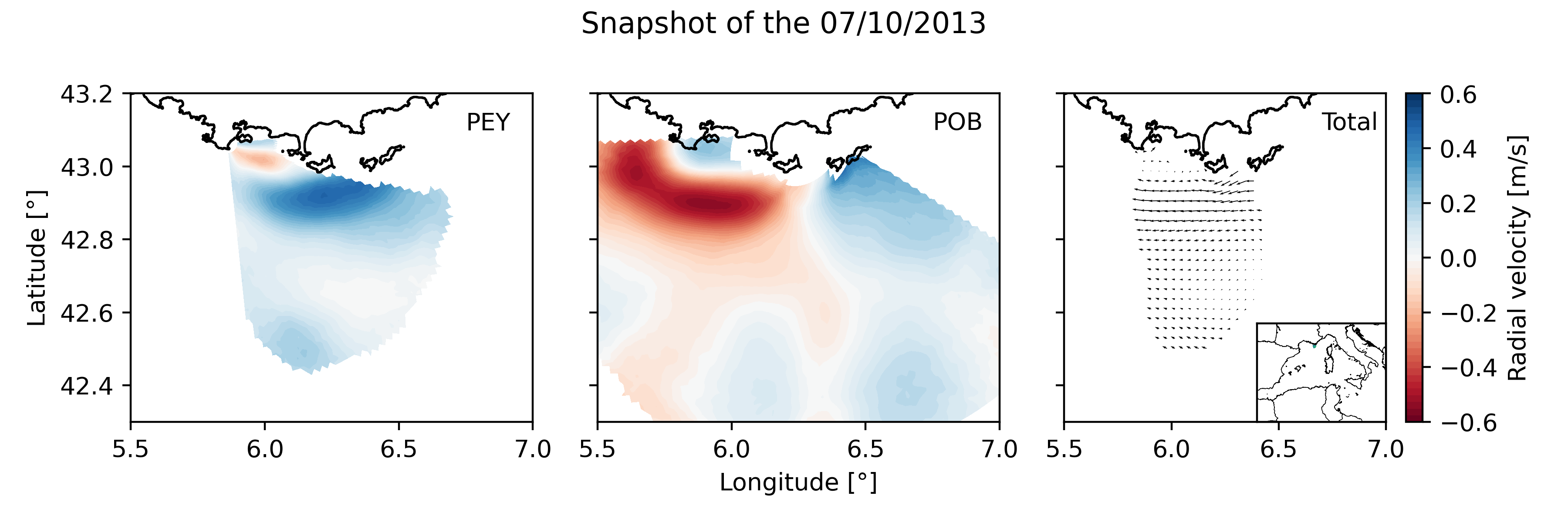
Daily High Frequency Radar (HFR) surface current data (radial velocity files and total velocity file) from 2 different stations located on the French Mediterranean coast (Toulon), spanning from January 2012 to December 2019. The radial datasets have been processed to remove outliers. Then, the gaps in the data have been filled using the DINEOF algorithm. The total velocity is then reconstructed from the filled radial velocity files, and projected onto a cartesian grid of 1km x 1km. The HFR data comes from two systems, one monostatic radar PEY (located at Fort Peyras, La Seyne sur mer), and one bistatic POB (emitter located at Cap Bénat - Bormes les Mimosas, and transmitter on Porquerolles Island). The HFR data is initially hourly sampled. To remove the outliers of the data, for each timestep, a Probability Density Function (PDF) is computed on the spatial gradient of each radial map. Pixels with a spatial gradient with a probability under 3% are removed. Additionnally, for each pixel, a PDF is computed on the temporal gradient of its whole timeseries. Timesteps with a temporal gradient that have a probability under 1% are then removed. Then we proceed to a preliminary temporal and spatial hole filling of the missing data. For the timeseries of each pixel, timesteps that are surrounded by valid values within 3 hours (i.e. 3 timesteps) are filled by a weighted linear interpolation. For each timestep, pixels of the map surrounded by values within 1 grid point are filled in the same way. The radial data is then daily averaged. The DINEOF algorithm (http://modb.oce.ulg.ac.be/mediawiki/index.php/DINEOF) is run in a multivariate way (2 radial velocity files) using 50 EOF modes for the reconstruction. At some timesteps (shown by the flag variable of the file), the filling has not been possible, and the missing maps have been replaced by the temporal average radial map. The filled radial velocities are then locally interpolated onto a cartesian grid of 1km spatial resolution using a Weighted Least Square method. HF radar sites : - Peyras : 43°03'47.4"N, 5°51'40.3"E - Porquerolles (transmitter only): 42°58'59.0"N, 6°12'15.3"E - Bénat (receiver only): 43°05'31.5"N, 6°21'26.5"E EUROPEAN DIRECTORY OF MARINE ENVIRONMENTAL RESEARCH PROJECTS (EDMERP) : - SICOMAR PLUS(12402), IMPACT(12271), MOOSE(11574), and JERICO NEXT(12227) EQUIPEMENTS: - High Frequency Surface Wave radar WERA from HELZEL MESSTECHNIK PARAMETERS: - sea surface current Citation: Molcard, A., & Bourg, N. (2021). HF RADAR - French Riviera (Mediterranean Institute of Oceanography) - daily surface currents filled with DINEOF [Data set]. MIO UMR 7294 CNRS. https://doi.org/10.34930/9263C4DF-4F55-4C5A-B183-C40EE1D844B1
-
"Towards an integrated prediction of Land & Sea Responses to global change in the Mediterranean Basin" The LaSeR-Med project aims at investigating the effects of climate change and of mediterranean population growth on some major indicators of the Mediterranean Sea (primary production, carbon export, zooplankton biomass available for small pelagic fishes, pH, dissolved oxygen) using and integrated model encompassing a socio-economic model, a continental model of agro-ecosystems, and a physical ocean-atmosphere model coupled to a biogeochemical model of the ocean. Last, a model for the widespread species of jellyfish Pelagia Noctiluca (Berline et al., 2013) uses biogeochemical outputs as food forcing for the jellyfish. In this project, our aim was first to investigate the large-scale and long-term impacts of variations in river inputs on the biogeochemistry of the Mediterranean Sea over the last decades (see Pages et al., 2020a). In the second phase, a climate scenario (RCP8.5) alone (Pages et al., 2020b) or combined with a “land-use” scenario derived to ensure the same level of food availability as today in 2050 have been run to investigate its effect on these indicators and to analyze the observed changes on the structure and the functioning of planktonic food web. This interdisciplinary project provided the framework for joint discussions on each of the sub-models that constitute the integrated model, namely the socio-economic model (Ami et al., in prep., Mardesic et al., in prep.) created ex nihilo by researchers from AMSE, INRA and GREQAM, the continental agro-ecosystem model LPJmL (Bondeau et al., 2007) worked on at IMBE so as to include the nitrogen and phosphorous cycles in the frame of the present project, and the ocean biogeochemical model Eco3M-Med developed at MIO (Baklouti et al., 2006; Alekseenko et al. 2014, Guyennon et al., 2015; Pagès et al., 2020a), forced by ocean physics, either using the ocean model NEMO-Med12 forced by atmosphere at IPSL (simulation NM12-FREE run with the NEMO-MED12 model and used for our hindcast simulation, see below) or a coupled ocean-atmosphere model at CNRM (physical forcing provided by CNRM-RCSM4, see below). Details on the CNRM-RCSM4 model The CNRM-RCSM4 simulates the main components of the Mediterranean regional climate system and their interactions. It includes four different components: (i) The atmospheric regional model ALADIN-Climate (Radu et al., 2008; Colin et al., 2010; Herrmann et al., 2011) characterized by a 50 km horizontal resolution, 31 vertical levels, and a time step of 1800 s, (ii) the ISBA (Interaction between Soil Biosphere and Atmosphere) land-surface model (Noilhan and Mahfouf, 1996) at a 50 km horizontal resolution, (iii) the TRIP (Total Runoff Integrating Pathways) river routing model (Oki and Sud, 1998), used to convert the runoff simulated by ISBA into rivers (Decharme et al., 2010; Szczypta et al., 2012; Voldoire et al., 2013), and (iv) the Ocean general circulation model NEMO (Nucleus for European Modeling of the Ocean, Madec and NEMO-Team, 2016) in its NEMO-MED8 regional configuration (Beuvier et al., 2010). NEMO-MED8 is characterized by a horizontal resolution of 1/8° (grid cells size from 6 to 12 km), a vertical resolution of 43 vertical levels (cell height ranging from 6 to 200 m), and a time step of 1200 s. More details about the CNRM-RCSM4 model can be found in Sevault et al. (2014). Keywords: - Mediterranean Sea, river inputs, chlorophyll, nutrients, phytoplankton, bacteria, zooplankton, dissolved and particulate organic detrital matter Citation: Pagès, R., Baklouti, M., Barrier, N., Richon, C., Dutay, J.-C., and Moutin, T. (2020a). Changes in rivers inputs during the last decades significantly impacted the biogeochemistry of the eastern Mediterranean basin: a modelling study. Prog. Oceanogr. 181:102242. doi:10.1016/j.pocean.2019.102242 Pagès, R., Baklouti, M., Barrier, N., Ayache, M., Sevault, F., Somot, S. and Moutin, T. (2020b). Projected Effects of Climate-Induced Changes in Hydrodynamics on the Biogeochemistry of the Mediterranean Sea Under the RCP 8.5 Regional Climate Scenario. Front. Mar. Sci. 7:563615. doi:10.3389/fmars.2020.563615 Ayache, M., Bondeau, A., Pagès, R., Barrier, N., Ostberg, S. and Baklouti, M. (2020). LPJmL-Med – Modelling the dynamics of the land-sea nutrient transfer over the Mediterranean region–version 1: Model description and evaluation. Geoscientific Model Development Discussions, Copernicus Publ.
-
Maupiti ("the Stuck Twins'') is a diamond-shaped island located in the western part of the Society archipelago in French Polynesia. The present study focuses on the data recovered over a single cross-barrier transect located in the south-west barrier during the MAUPITI HOE field campaign, from 5 to 18 July 2018. The studied area is representative of the reef structure observed along the 4km-long southwestern barrier reef, showing an alongshore-uniform structure exposed to swell approaching with weak incident angles, a healthy reef colony. In the cross-barrier direction, the reef displays a clear partitioning of bottom roughness that ranges from low-crested compact structures at the reef crest to higher and sparser coral bommies on the backreef. The experimental setup was specifically designed to analyse and differentiate the dynamics over three roughness-contrasting sections found over the barrier reef. The scientific objectives of the project MAUPITI HOE are to understand the hydrodynamics of an archetypal reef-lagoon system of a high volcanic reef island. The physical functioning of the hydrosystem involves a fine coupling between water levels, waves (including wind, infragravity and VLF waves), currents and seabed structure (reef roughness). Four pressure sensors (OSS3, OSS4, OSS5, OSS6) have been deployed across the reef flat/ backreef, outside the surf zone. The bottom pressure is measured continuously at 10 Hz, and are converted into free surface elevation assuming hydrostaticity. An electrocurrent meter S4 provides the wave forcing while AQP1 is a velocity profiler providing the transports. The bed profile is obtained from the combination of (I) boat survey in the deeper part and (ii) high resolution GNSS RTK topography by feet. Two datasets are available: one is concerning the mean parameters linked to the reef barrier dynamics, and the second dataset is concerning the wave friction.
-
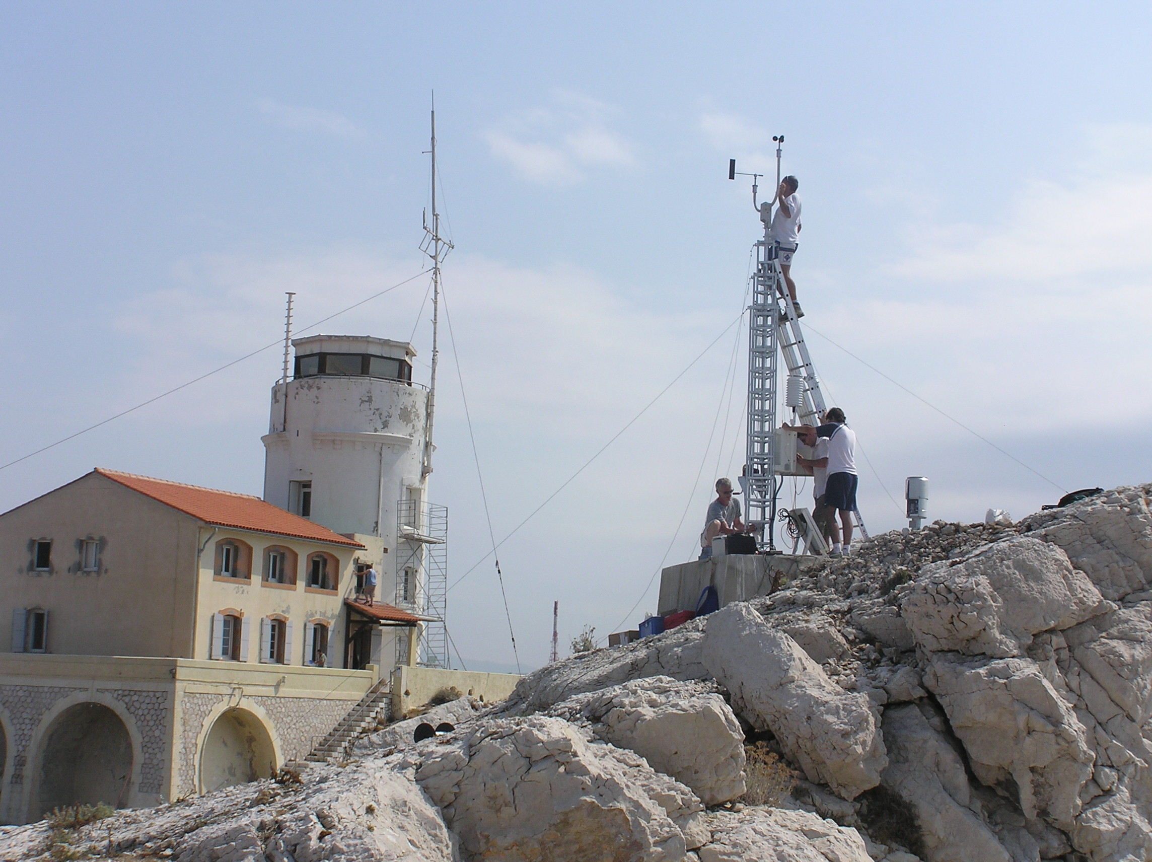
Meteorological data from the Bay of Marseille based on the measurements taken on the site located on the Pomegues island SITE : Iles de Pomègues – Sémaphore du Frioul - Latitude 43°15’59 N - Longitude 5°17’39 W - Hauteur : 25 m PROGRAMME DE RATTACHEMENT : - Mediterranean Oceanic Observing System on Environment : MOOSE - SOMLIT - Labellisation : SOERE - INSU - Financement : SOERE – INSU Read the abstract and supplemental information provided in the Vector template for more details. EQUIPEMENTS: - Station météorologique Auria avec transmission temps réel - Anémomètre et girouette - Baromètre - Pyranomètre - pluviomètre PARAMETRES MESURES : - Vent ( vitesse et direction) - Température et pression atmosphérique - Irradiance - Pluie DISPONIBLITE DES DONNEES : - Visualisation temps réel - Base de données du Service d'Observation du MIO RESPONSABLE : P. Raimbault. PARTICIPANTS : - M. Fornier (Tech Univ) et M. Lafont (Tech Univ) : maintenance - C. Yohia : gestion des données – site web PARTENAIRES : - MOOSE - SOMLIT – MERMEX – CHARMEX -Ville de Marseille - Parc des îles du Frioul -CITATION : Raimbault, P., & Yohia, C. (2017). Météorologie locale en baie de Marseille : Frioul [Data set]. MIO UMR 7294 CNRS. https://doi.org/10.34930/5C9F6377-726B-436B-AA0F-ECC32803EF88
-
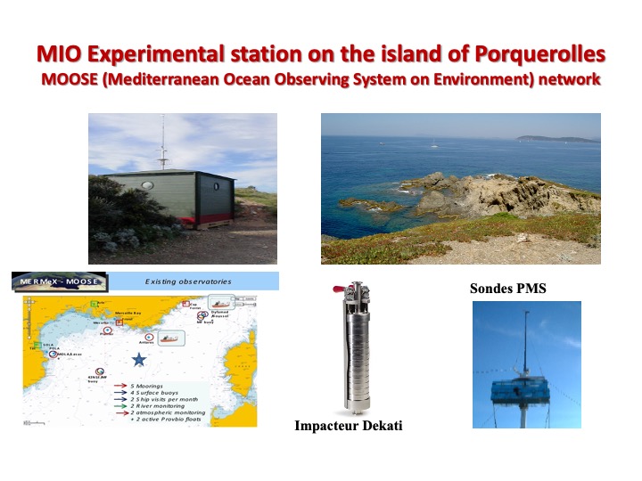
OBJECTIFS: Mesures physicochimiques des concentrations d’aérosols et des paramètres météorologiques classiques (Pression, Température, humidité, vitesse et direction du vent). DESCRIPTION: Le site de Porquerolles offre la possibilité d’investiguer la charge atmosphérique en aérosols, notamment pour les conditions des vents dominants dans la région, vent d’Est et Mistral. La station de mesures et d’observation que le laboratoire a installée à Porquerolles est située à l’extrême ouest de l’île au lieudit du « Grand Langoustier » (43 ° 00’ 06’’N- 6° 09’35’’E). Cette station est dédiée à l’étude des sources et de la dynamique de l’aérosol atmosphérique. Elle est équipée de capteurs qui fournissent le spectre granulométrique des aérosols de taille allant de 0.01 à 95 µm. Pour les tailles de particules allant de 0.5 à 95 µm, les instruments utilisés sont des capteurs optiques fonctionnant sur le principe de la théorie de Mie placés à l’extérieur sur un mât de cinq mètres de hauteur, les sonde PMS (Particle Measurement System). Au cours des années, il a été utilisé successivement les sondes ASASP-X et CSASP (1999-2019) puis les CSASP-100-HV-ER et la CSASP -200 à partir de 2019. Pour les aérosols de tailles inférieures à 0.5 µm, un classificateur électrostatique, le système SMPS-DMA est installé à l’intérieur fournissant le spectre granulométrique pour les aérosols couvrant les tailles de 0.01 à 0.5 µm. Afin d’analyser la composition des aérosols, on utilise ponctuellement un impacteur « en cascade » qui prélève les aérosols par aspiration à partir d’une série de filtres placés à différents étages constituant un système de tamis qui permet de sélectionner des particules de différentes tailles entre 0.5 et 7 µm. L’analyse chimique pour identifier la composition des échantillons d’aérosols se fait après-coup en laboratoire à partir le plus souvent de chromatographie ionique. RESPONSABLE LOCAL: Jacques Piazzola RESPONSABLE TECHNIQUE: Tathy Missamou PARTICIPANTS: Gilles Tedeschi, Remi Chemin PARTENAIRES- MOOSE –ONERA et DGA - OSU de Villefranche et de Banyuls